|
Al-Ahram Weekly 11 - 17 March 1999 Issue No. 420  Fatimid Cairo is at present the object of intensive transformations and restoration work, but there is little consensus as to the right way of saving this historic part of the city, classified by UNESCO as part of the international cultural heritage. With a new book, Historic Cairo: A Walk Through the Islamic City, by Jim Antoniou, out this week, and an exhibition, Around the Two Palaces, organised by a team of French students and professors of architecture, Fayza Hassan journeys through layers of history, and listens to recommendations for a renaissance
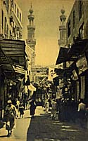
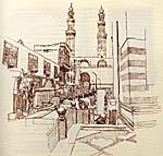
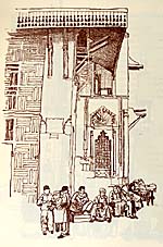
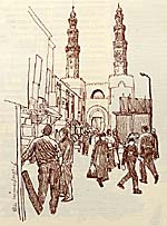
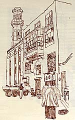
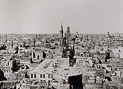
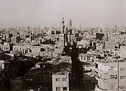
Fatimid Cairo has become the centre of attention -- and debate -- in the past few years: several mosques, sabils and wikalat have been or are being restored, work on Al-Azhar Mosque is now completed, the tunnel under Al-Azhar Street is proceeding at a regular pace, and the much maligned Mashyakha, given a last-minute reprieve from the wrecking ball, still stands in Al-Hussein Square, which is nevertheless being given a comprehensive facelift. Shopkeepers of the area continue to worry about their uncertain fate. Meanwhile, specialists argue back and forth, for and against the restoration work now underway. Amidst the flurry, two coincidental and unrelated events -- the exhibition, at Beit Al-Harawi, of professional studies presenting possible solutions for the rehabilitation of Fatimid Cairo; and the launching, at Al-Ghouri Palace, of a new book, Historic Cairo, A Walk Through the Islamic City, just published by the American University in Cairo Press -- are further enticements to examine once more the different options. Should Fatimid Cairo be transformed into a museum, reserved solely to convoys of tourists, or should it be the patrimony of its present users, whose daily activities, if left unchecked, are bound to damage the precious monuments irredeemably? The book: Historic Cairo is written and illustrated by Jim Antoniou (RIBA, MRIPI, FRSA), a British architect, city planner and author of several authoritative volumes on conservation, who has been involved in various historic Cairo projects over the years, as a consultant to the Egyptian Supreme Council of Antiquities for UNESCO. He was recently commissioned by the UN Development Programme to advise on all aspects of the Rehabilitation of Historic Cairo Project, in his capacity as senior consultant. The exhibition: presented in the context of Horizons Partagés (Shared Horizons, commemorating 200 years of Franco-Egyptian cultural relations), it is the result of an ongoing three-year project, Autour des Deux Palais (Around the Two Palaces), produced by the students of L'Atelier Le Caire (the Cairo Workshop) at the Schools of Architecture of Versailles and Paris-Belleville, in collaboration with Al-Azhar University. It aims at redefining public space and reinforcing the urban fabric of Fatimid Cairo, while maintaining the presence of the inhabitants with their commercial and artisanal activities, and generally improving the environment and quality of life in the area.
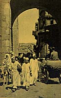
While Antoniou's fresh approach endeavours to describe in great detail the situation on the ground through an academically informed walk across the Islamic city (original illustrations by the author support the historical narrative and description of the monuments), the Atelier Le Caire addresses practical issues, offering a series of maps as a basis to imagined interventions and pragmatic solutions designed to alleviate the terminally harmful problems plaguing the quarters at present. Both presentations are therefore complementary and, combined, will afford the relatively uninitiated visitor an enlightened assessment of what, exactly, is at stake. In recent years, many specialists, appalled at the rapid destruction of the numerous monuments of Fatimid Cairo, of which the fire at the Musaferkhana is one of the most notable -- and regrettable -- examples, have clamoured for the relocation of the inhabitants and the transformation of the area into an historical reserve, a theme park of sorts, supported financially by income from tourism, which will allow for a programme of steady restoration and maintenance. Plans have been submitted which include, among other suggestions, a large pedestrian square bordered by Al-Azhar at one end and Al-Hussein at the other, lots of green space, quaint "Oriental" cafés, artists' ateliers, indigenous arts and crafts workshops and souvenir boutiques... This artificial paradise will give tourists ample space to survey the collection of spotless, freshly painted monuments at leisure, while listening to tour guides sigh nostalgically about "the way it was when real people lived here". "This is mad," say both Sawsan Noweir, assistant professor at the Ecole d'Architecture de Versailles and Christiane Blancot, architect and urban planner attached to the Municipality of Paris, who have accompanied the Versailles students presenting the project. "This is a prosperous, dynamic part of Cairo. Tourists are as attracted by the hustle and bustle of real activities as they are by the mosques and palaces." Although part of the Fatimid city has been built over an existing cemetery, it was never meant to revert to its original function, says Noweir. "This is how it will look, though, if you get rid of the people." Interestingly enough, the Fatimids themselves shunned the isolation of the cemeteries near Fustat and preferred to bury their noble dead in splendid mausolea within the confines of the city. "Not only should the original occupants stay," says Noweir, "they should be actively encouraged to take up residence in the quarter." Blancot notes that many tenements are now used as depots by their owners, who have moved to more fashionable quarters. "There are fantastically beautiful apartments in this area," she comments, "featuring at least part of the original stone walls with high, hand-painted ceilings, carved wooden doors and magnificent proportions. Why not create warehouses somewhere nearby, and use the accommodation thus freed as private homes? In many parts of the world, professional people are abandoning the suburbs and moving back downtown. Wouldn't such a move make good sense in a city plagued by traffic problems?" In fact, until the turn of the century, the quarters of Gamaliya, Batniya, Al-Darb Al-Ahmar and their adjoining alleys were both residential and commercial, inhabited by a whole population of prosperous (or not so prosperous) craftsmen, tradesmen, shopkeepers, café and restaurant owners, and government employees whose families were born, lived, worked and often died on the same street, without so much as venturing out of the quarter. In Palace Walk, an aura of danger hovers over Sitt Amina when, disobeying her husband's orders, she steps out of the cozy house she has not left since her marriage -- except for short, chaperoned carriage trips to visit her mother in nearby Khurunfish -- into the cul-de-sac known as Qasr Al-Shawq, on her way to Al-Hussein Mosque. "She was gripped by intense embarrassment as she showed herself to the eyes of people she had known for ages but only through the peephole of the enclosed balcony... She began to ask Kamal about the sights, buildings and places they encountered on the way... Here was the famous vaulted ceiling of Qirmiz Alley... This was Beit Al-Qadi Square with its tall trees... This large building was the Gamaliya police station... They went on until they reached Khan Ja'far Primary School, where Kamal had spent a year before enrolling at Khalil Aga Elementary School... After that, they turned into Khan Ja'far Alley. Then in the distance they could see part of the exterior of the mosque of Al-Hussein... She began to compare what she saw with the picture created by her imagination and based on what she had seen from her home of mosques like Qala'un and Barquq. She found the reality to be less grand than she had imagined." Sitt Amina's punishment for having allowed herself a glimpse of her quarter is one of the most famous episodes of Mahfouz's trilogy. "When one lives on a street," comments Blancot, "one has a personal stake into its general maintenance, as opposed to the lack of regard one may experience for one's place of work. Inhabitants of a quarter have a vested interest in establishing services, improving garbage collection and the sewage network. They are mindful of the overall aspect of their street. If a number of dwellers in the adjoining quarters endeavour to clean up their immediate neighbourhood, the area's problems may be lessened considerably." In the absence of massive funding to support a restoration mega-project, the team of students and their professors recommend a number of small, on-the-spot interventions, which in the long run can extend into one large improvement of the present situation.
Noweir could not agree more: "The area we have been looking at comprises the qisms of Gamaliya and Darb Al-Ahmar. It is a centre of production, commercial and craft-related activities on a national scale. It contains 120 classified historical monuments and a population of 137,000 competing for a little over 7.50 square kilometres." Antoniou's main concern, however, is to provide an overview of the situation, not suggest practical steps toward reorganisation. Blancot explains: "We have to understand that the area is choking. It is being damaged by overpopulation, inadequate services, extensive pollution produced by the traffic and factories that have been established in contravention of the existing regulations. Furthermore, there are no green spaces to provide a breath of fresh air. These problems can be solved, however, without necessarily taking drastic measures such as simply getting rid of the people." Actually, the French team do not even believe most of the recent constructions crowding the monuments should be removed. "There is an aluminium factory behind Khurunfish which causes considerable pollution, and the ophthalmic hospital built on the foundations of the Qala'un maristan would have to go too because of the water damage it is responsible for," says Blancot; "but the rest can definitely be worked into a more conservation-friendly environment." The students of the Atelier Le Caire have been devising solutions along precisely these lines. The Atelier Le Caire suggestions: 1. Organising the outside limits of the Fatimid city, including Galal Street and the surrounding wall to the north; Ahmed Maher/Al-Darb Al-Ahmar Street and the surrounding wall to the south; Mansuriya Street and the surrounding wall to the east; and, to the west, Al-Khalig/Port Said Street. 2. Organising the main thoroughfares of Al-Mu'izz, Al-Gamaliya and Al-Azhar. 3. Organising the quarters of Gamaliya, Batniya, Darb Sa'ada and Khurunfish. Galal Street is of crucial importance, posing serious problems because of its irregular width, on one hand, and its present incapacity to cope with the continuous and intense flow of traffic, on the other. Galal Street, however, offers opportunities for a range of alterations which should be carried out in conjunction with the restoration of the Fatimid walls. Doubling as a ring-road around downtown Cairo, it could be enlarged into a two-way thoroughfare -- featuring large sidewalks for easier pedestrian circulation -- and become a major axis for city traffic. It should comprise three well-defined intersections with Al-Mansuriya, Al-Husseiniya and Port Said streets. Trees could be planted on both sides of the street and shaded parking areas planned at strategic points. East of Bab Al-Nasr, along the Northern Wall, a shaded pedestrian promenade should be established and a small lane created to separate the wall from the encroaching dwellings. A small tree-planted square including a fountain could front Bab Al-Nasr and the adjoining wikala, while a larger square around Bab Al-Futuh could encompass the planted area already established in front of Al-Hakim Mosque. Mansuriya Street links the Fatimid city with Abbassiya and Salah Salem Street. Should it be extended south, it could become another ring road to avoid the city centre, heading due east. Only untrammelled in the vicinity of Bab Al-Wazir, the Eastern Wall has sunken below street level at its northern end. At present, this portion of the wall is flanked by some 200 ishash (makeshift huts). According to Noueir, the inhabitants of these shacks have been promised apartments in Salam City, and would not mind moving, but no further steps have been taken to transfer them. Following the wall towards Al-Azhar, one can see it disappear under mounds of debris. Southwards, near the tower of Bab Al-Mahrouq, its city side is entirely obscured by buildings while its back, facing the hills, is buried under heaps of garbage. The students suggest the extension of Al-Mansuriya Street up to the Citadel, and the creation of a promenade along the eastern, elevated side of the East Wall with a garden on the lower, western edge. This could extend into a sort of raised terrace, built to accommodate several shops and fashionable cafés. The parking area of Al-Mansuriya should be enlarged with a tree-shaded annex, reaching to the area of the old book market. The old Darrassa factories which have fallen into disuse should be remodelled and leased to artisans, thus increasing the commercial importance of the quarter. To complete the facelift, the debris choking the wall should be excavated inside and outside Al-Batniya quarter and the recovered areas transformed into a garden on one side and a pedestrian lane on the other. Ahmed Maher/Al-Darb Al-Ahmar Street, starting at the limit of the Southern Wall, liaises between Bab Al-Wazir, Ataba, Tahrir Square and Ramsis Street. It is continuously plied by buses and heavy trucks, compounding traffic problems and creating regular bottlenecks in the environs of Bab Zuweila. Clearing the rubble at the eastern end of the wall would help increase the width of the street, which should be enlarged further and endowed with footpaths wide enough to accommodate the important craft-related activities which are the trademark of this area. The creation of small midans around the Al-Ishaqi complex, the Umayyad and Al-Salih Tala'i mosques, and the zawiya of Farag Ibn Ayyoub would further aerate the street, which should be extended to the east towards the wall and the new garden area of Al-Batniya. Al-Mu'izz and Gamaliya streets: Al-Mu'izz Street is the historic axis of Fatimid Cairo. Over 30 classified monuments line it between Bab Al-Futuh and Bab Zuweila. It is, with Al-Gamaliya Street, the most important commercial thoroughfare of the old city. The extreme narrowness of this vital artery (seven to eight metres) hampers traffic, which is constantly endangering the adjoining monuments due to its recklessness and density. The blueprint realised by the Atelier students attempts to solve these problems, by recommending a careful regulation of traffic, the strict enforcement of a no-parking policy in both Al-Mu'izz and Gamaliya during the day, the enlargement of the thoroughfare wherever possible by removing makeshift encroachments, the establishment of covered footpaths in front of the shops and the protection of the Qala'un complex by bordering it on the street side with a regular footpath and surrounding it on a lower level with a pedestrian lane close to the monument. Gardens and planted squares should surround Bab Al-Futuh, Bab Zuweila and all the important structures. Port Said Street, established when the old canal, Al-Khalig Al-Masri, was filled in to accommodate the new tram line, marks the western limits of the Fatimid city. Its width now varies between 30 and 70 metres. It is one of Cairo's busiest streets, particularly at the crossroads of Al-Azhar and Al-Muski streets. Since it is extremely dangerous to cross, the students are suggesting a central, 20m-wide two-way carriageway, edged with a large, tree-planted sidewalk, which at certain points can be shaped into small gardens with benches, or at others into informal roadside markets to replace the two markets which at present badly obstruct the flow of traffic. Parking lots and bus stops should be provided in sufficient numbers and traffic should be redirected around the midans of Al-Geish, Al-Azhar, Mohamed Ali and Ahmed Maher. A new network of roads should be created, linking Port Said Street and the Fatimid city. Finally, a garden in front of Qadi Yehia Mosque will add an extra spot of greenery.
Al-Azhar Street is a thoroughfare featuring a bridge which was built during the second half of this century in the mistaken belief that it would ease the traffic. It cuts the Fatimid city into two parts which are linked by a tunnel near Al-Azhar Mosque and an overhead pedestrian bridge in front of Al-Ghouri Mausoleum. It presents the most serious problems. At present, a tunnel is being dug underneath in an effort to free the area of vehicles. Experts' opinions are mixed as to the wisdom of this attempt but the Atelier Le Caire team regard it as a positive move. The project shows the mosques of Al-Azhar and Al-Hussein connected by a large midan, Al-Azhar Street transformed into a stately boulevard bordered by renovated buildings, its large sidewalks ornamented with palm trees and lined with shops, cafés and restaurants. The Al-Ghouri complex overlooks a small square featuring more trees. New low buildings in matching style are foreseen on several of the surrounding empty lots which may be used for various commercial activities. Darb Sa'ada: the space here is shared by two main activities: wholesale and retail stores dealing in fabrics in the quarter of Darb Sa'ada extending to the mosque of Baybars Al-Khayyat, and the manufacture and repair of furniture occupying the quarter of Taht Al-Rab'. Traffic is hampered by the presence of a large administrative centre attached to the Interior Ministry and a prison situated to the west of the area. The students are suggesting the establishment of several midans, in front of the mosque of Baybars Al-Khayyat, the hammam of Al-Mu'ayyad, the wikala and hammam Al-Sharaibi, and Al-Arabi Mosque. Furthermore, they feel that any new construction should not exceed the existing buildings in height. A boulevard linking the administrative complex to the prison, and the establishment of an "official" parking lot, would go a long way toward easing traffic congestion. Khurunfish: this sector includes the quarters of Al-Sha'rawi, Al-Khurunfish, Bein Al-Sourein, Gawhar Al-Qa'id and Al-Hamzawi. The entire area suffers from a lack of thoroughfares between the various quarters and from the damaging presence of an aluminium factory which is incompatible with the nature of the surroundings: with an extremely high population density and scarce, overcrowded alleyways preventing proper ventilation, noxious fumes and industrial pollution are choking the entire sector. The students propose the transfer of the aluminium factory out of Khan Abu Taqqiya; limits on the height of any new buildings; the creation of a north-south thoroughfare, using the existing infrastructure where possible; the opening up of blind alleys to create east-west connections between Port Said and Al-Mu'izz streets; the establishment of small squares and gardens whenever possible, one of which could be situated on the vacant lot now used as a garbage dump in the Sagha (Goldsmiths) quarter; the transformation of another empty lot, opposite Al-Bohar Mosque, into a playground; and finally, the incorporation of a large midan into the space between the school and the synagogue. Gamaliya: this sector includes the quarters of Bab Al-Futuh, Al-Outouf, Darrassa, Al-Hussein, Qasr Al-Shawq and Khan Al-Khalili. Describing Gamaliya and outlining its problems, Jacques Berque wrote in the '70s: "Anyone leaving the mosque of Sayidna'l Hussein to go towards the old gates of Cairo, Bab [Al-] Nasr and Bab Al-Futuh, must pass through the old district of Al-Gamaliya, which is relatively unchanged; even today it retains some of its character. But of course it is now densely populated. In keeping with the growth rate of the city, Gamaliya has now 150,000 inhabitants... The density in this district exceeds three persons per room. The mass of humanity living among these old stones, on the debris of the old Fatimid city, suffers from a kind of decline which is the corollary of its original nobility." (Imperialism and Revolution, Faber and Faber, 1971) The proposed interventions by the Atelier Le Caire include a north-south thoroughfare cutting across the quarters of Al-Outouf, Qasr Al-Shawq and Al-Hussein; a pedestrian zone linking Khan Al-Khalili and Bab Al-Futuh; an archaeological garden at the back of the Qala'un complex showcasing the vestiges of the Eastern Fatimid Palace, presently buried under tons of rubble; and the removal of the aluminium factory. Furthermore, it will be necessary to open up another thoroughfare running on an east-west axis, starting at the Eastern Wall and leading to the monuments of Al-Gamaliya and Al-Mu'izz streets; to create squares, playgrounds and craft centres on the existing empty lots; to transform the square of Beit Al-Qadi which is blocked by a police station; and finally, to create a quarter similar to Khan Al-Khalili on the wasteland behind Al-Hakim Mosque, in order to revitalise the entire northern sector.
A communication network starting with Batniya/Midan Al-Muski Street could act as a main thoroughfare. Dead-end alleys could be opened onto Haret Al-Roum, which in turn should be opened onto Al-Darb Al-Ahmar Street; another good move would be to reopen the street which the book market occupies, running between Al-Azhar Mosque and Al-Azhar University. Debris should be cleared off the Eastern and Southern walls, which could then be surrounded with footpaths, gardens and pedestrian zones; playgrounds and gardens should be added around the schools and the houses of Gamaleddin Al-Dahabi and Al-Shabshiri as well as the wikala of Nafissa Al-Baydaa. Plans should also be drawn up to enlarge Fatma Al-Nabawiya and Bab Al-Mahrouq squares.
While Antoniou presents us with the Fatimid city as it is now, the Atelier Le Caire is suggesting how it should change in order to be saved. Can we reverse the tide, then, without altering the spirit of the place? Has this spirit not mysteriously endured through many centuries and many changes? "In Cairo, for instance, even the most summary archaeological analysis reveals the density of the social connotations implicit in the majestic porch of Bab Zuweila," writes Berque. "If we could count all the historical memories associated with this monumental entrance-gate, the legends, tombs, holy places and ritual symbols, we might perhaps succeed in defining and even quantifying these associations. Thus we might discover the enduring nature of the city."
|